Geolocate

Caguas topographic map

Click on the map to display elevation.

About this map

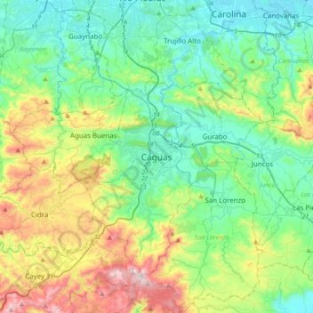
Name: Caguas topographic map, elevation, terrain.

Location: Caguas, Puerto Rico, 00725, United States (18.07454 -66.19513 18.39454 -65.87513)

Average elevation: 241 m

Minimum elevation: 0 m

Maximum elevation: 885 m

Other topographic maps

Click on a map to view its topography, its elevation and its terrain.

Beatriz

United States > Puerto Rico > Caguas > Caguas

Average elevation: 362 m

Gear up for your next adventure:

🔦LED Headlamp - Hands-free lighting for early morning starts or late finishes
🧥Thermal Fleece Jacket - Versatile insulation for changing mountain temperatures
Camping Groundsheet - Protect your tent from moisture and dirt
💧Hydration Pack - Hands-free hydration system for long hikes
🔥Emergency Fire Starter - Reliable ignition source for all weather conditions

As an Amazon Associate, this site earns from qualifying purchases at no extra cost to you.