
Fort Frances topographic map
Click on the map to display elevation.
About this map
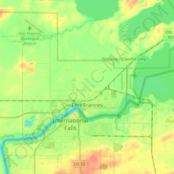
Name: Fort Frances topographic map, elevation, terrain.
Average elevation: 343 m
Minimum elevation: 323 m
Maximum elevation: 368 m
Rainy River District trails, hiking, mountain biking, running and outdoor activities
Other topographic maps
Click on a map to view its topography, its elevation and its terrain.
Otukamamoan Lake
Canada > Ontario > Rainy River District > Unorganized Rainy River
Average elevation: 368 m
Stratton
Canada > Ontario > Rainy River District > Morley Township > Stratton
Average elevation: 346 m
French River
Canada > Ontario > Rainy River District > Unorganized Rainy River
Average elevation: 439 m
Little Eva Lake
Canada > Ontario > Rainy River District > Unorganized Rainy River
Average elevation: 357 m
Helmet Lake
Canada > Ontario > Rainy River District > Unorganized Rainy River
Average elevation: 454 m