
Mörsdorf topographic map
Interactive map
Click on the map to display elevation.
About this map
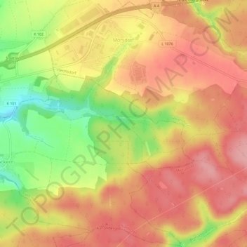
Name: Mörsdorf topographic map, elevation, terrain.
Average elevation: 330 m
Minimum elevation: 255 m
Maximum elevation: 376 m
Other topographic maps
Click on a map to view its topography, its elevation and its terrain.
Eichenberg
Duitsland > Thüringen > Saale-Holzland-Kreis
Eichenberg, Südliches Saaletal, Saale-Holzland-Kreis, Thüringen, Duitsland
Average elevation: 258 m
Weißbach
Duitsland > Thüringen > Saale-Holzland-Kreis > Weißbach
Weißbach, Hügelland/Täler, Saale-Holzland-Kreis, Thüringen, Duitsland
Average elevation: 308 m