
Ventspils topographic map
Interactive map
Click on the map to display elevation.
About this map
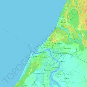
Name: Ventspils topographic map, elevation, terrain.
Location: Ventspils, Courland, Latvia (57.34799 21.51722 57.47055 21.67404)
Average elevation: 4 m
Minimum elevation: -2 m
Maximum elevation: 27 m
Other topographic maps
Click on a map to view its topography, its elevation and its terrain.
Stende
Latvia > Courland > Talsu novads
Stende, Talsu novads, Courland, LV-3257, Latvia
Average elevation: 87 m
Dienvidkurzemes novads
Latvia > Courland > Dienvidkurzemes novads
Dienvidkurzemes novads, Courland, Latvia
Average elevation: 43 m