Geolocate

Plage topographic map

Click on the map to display elevation.

About this map

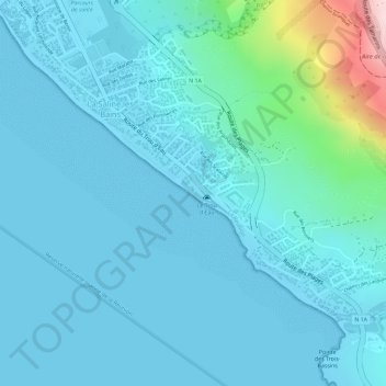
Name: Plage topographic map, elevation, terrain.

Location: Plage, Route du Trou d'Eau, Les Sables Blonds, Saint-Paul, La Réunion, 97434, France (-21.10095 55.24332 -21.10085 55.24342)

Average elevation: 41 m

Minimum elevation: 0 m

Maximum elevation: 319 m

Other topographic maps

Click on a map to view its topography, its elevation and its terrain.

Ravine de la Saline

France > La Réunion > Saint-Paul > La Saline

Average elevation: 591 m

Ravine Bernica

France > La Réunion > Saint-Paul

Average elevation: 819 m

Ravine Renaud

France > La Réunion > Saint-Paul > Bellemène

Average elevation: 614 m

Ravine de la Saline

France > La Réunion > Saint-Paul > La Saline

Average elevation: 370 m

Gear up for your next adventure:

🔦LED Flashlight - Powerful and long-lasting flashlight for camping and emergencies
🚑Survival Whistle - Signal for help across long distances in mountains
🛶Waterproof Dry Bags - Keep electronics and clothes dry during river crossings
👟Sport Hiking Sandals - Breathable footwear for water crossings and camp rest
🔋Lithium AA Batteries - Long-lasting power that performs in extreme cold

As an Amazon Associate, this site earns from qualifying purchases at no extra cost to you.