Geolocate

Hovden topographic map

Click on the map to display elevation.

About this map

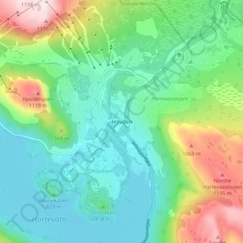
Name: Hovden topographic map, elevation, terrain.

Location: Hovden, Bykle, Agder, 4755, Norway (59.54024 7.33602 59.58024 7.37602)

Average elevation: 875 m

Minimum elevation: 750 m

Maximum elevation: 1,184 m

Other topographic maps

Click on a map to view its topography, its elevation and its terrain.

Tvedestrand

Norway > Agder

Average elevation: 75 m

Lygna

Norway > Agder

Average elevation: 273 m

Kristiansand

Norway > Agder

Average elevation: 76 m

Gear up for your next adventure:

💡Solar Camping Lamp - Eco-friendly lighting for campsites
🕯️Camping Lantern - Illuminates your entire campsite with high-efficiency LEDs
🥾Mountaineering Boots - Supportive boots for climbing and high-altitude hiking
🛌Insulated Sleeping Pad - Critical thermal barrier between you and the cold ground
🥾Approach Shoes - Shoes designed for climbing approaches and rugged trails

As an Amazon Associate, this site earns from qualifying purchases at no extra cost to you.