
Make a donation
Gear up for your next adventure:
As an Amazon Associate, this site earns from qualifying purchases at no extra cost to you.
Utarp topographic map
Click on the map to display elevation.
Make a donation
Gear up for your next adventure:
As an Amazon Associate, this site earns from qualifying purchases at no extra cost to you.
About this map
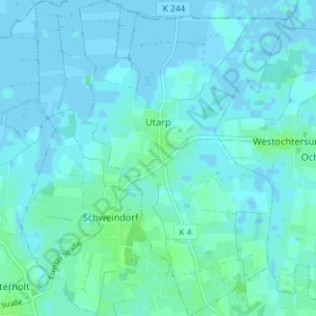
Name: Utarp topographic map, elevation, terrain.
Average elevation: 2 m
Minimum elevation: -3 m
Maximum elevation: 8 m
Make a donation
Gear up for your next adventure:
As an Amazon Associate, this site earns from qualifying purchases at no extra cost to you.
Other topographic maps
Click on a map to view its topography, its elevation and its terrain.
Make a donation
Gear up for your next adventure:
As an Amazon Associate, this site earns from qualifying purchases at no extra cost to you.
Leerhafe
Deutschland > Niedersachsen > Landkreis Wittmund > Wittmund
Besiedlungshinweise sind in Leerhafe schon sehr früh nachzuweisen. So finden sich in der Nähe des Ortes Hügelgräber aus der Bronzezeit. Um 1400 wird der Ortsname Leerhave auf einer Kirchenglocke benannt. Aber schon 1350 wird urkundlich der Ort de Wyllale erwähnt, der abgewandelt auf das lateinische ville…
Average elevation: 6 m
Make a donation
Gear up for your next adventure:
As an Amazon Associate, this site earns from qualifying purchases at no extra cost to you.
Make a donation
Gear up for your next adventure:
As an Amazon Associate, this site earns from qualifying purchases at no extra cost to you.
Make a donation
Gear up for your next adventure:
As an Amazon Associate, this site earns from qualifying purchases at no extra cost to you.
Negenbargen
Deutschland > Niedersachsen > Landkreis Wittmund > Wittmund > Jackstede
Average elevation: 4 m
Fulkum
Deutschland > Niedersachsen > Landkreis Wittmund
Der Ort liegt auf Höhen zwischen drei und fünf Metern über Normalnull etwa fünf Kilometer westlich von Esens. Der Ortsteil umfasst neben Fulkum auch die Wohnplätze Hartsgast, Groß- und Klein-Fulkum sowie die Bauerschaften Nord- und Süd-Uppum. Mit diesen bildet Fulkum ein eigenes Kirchspiel, dessen…
Average elevation: 1 m
Make a donation
Gear up for your next adventure:
As an Amazon Associate, this site earns from qualifying purchases at no extra cost to you.
Eggelingen
Deutschland > Niedersachsen > Landkreis Wittmund > Wittmund > Eggelingen
Average elevation: 1 m
Make a donation
Gear up for your next adventure:
As an Amazon Associate, this site earns from qualifying purchases at no extra cost to you.
Oldendorf
Deutschland > Niedersachsen > Landkreis Wittmund > Wittmund > Buttforde > Oldendorf
Average elevation: 1 m
Make a donation
Gear up for your next adventure:
As an Amazon Associate, this site earns from qualifying purchases at no extra cost to you.
Nenndorf
Deutschland > Niedersachsen > Landkreis Wittmund > Wittmund > Nenndorf
Average elevation: 2 m
Amerika
Deutschland > Niedersachsen > Landkreis Wittmund > Friedeburg > Amerika
Average elevation: 5 m
Wehle
Deutschland > Niedersachsen > Landkreis Wittmund > Wittmund > Ardorf > Wehle
Average elevation: 5 m
Burmönken
Deutschland > Niedersachsen > Landkreis Wittmund > Wittmund > Burmönken
Average elevation: 2 m
Make a donation
Gear up for your next adventure:
As an Amazon Associate, this site earns from qualifying purchases at no extra cost to you.