Geolocate

Balvano topographic map

Click on the map to display elevation.

About this map

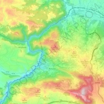
Name: Balvano topographic map, elevation, terrain.

Location: Balvano, Potenza, Basilicata, Italy (40.62821 15.46521 40.69807 15.57843)

Average elevation: 622 m

Minimum elevation: 234 m

Maximum elevation: 1,222 m

Other topographic maps

Click on a map to view its topography, its elevation and its terrain.

Agri

Italy > Basilicata > Potenza > San Martino d'Agri

Average elevation: 491 m

Gear up for your next adventure:

🧢Hiking Sun Hat - Wide-brimmed protection for exposed mountain ridges
🦌Outdoor Trail Camera - Monitor wildlife activity near your favorite spots
🥾Hiking Gaiters - Protect legs and shoes from mud, snow, and debris
👟Trail Running Shoes - Agile footwear for fast-paced topographic exploration
🩹Compact First Aid Kit - Pre-packed essentials for common trail injuries

As an Amazon Associate, this site earns from qualifying purchases at no extra cost to you.