
Thank you for supporting this site ❤️
Make a donation
Make a donation
Gear up for your next adventure:
As an Amazon Associate, this site earns from qualifying purchases at no extra cost to you.
Kadıköy topographic map
Click on the map to display elevation.
Thank you for supporting this site ❤️
Make a donation
Make a donation
Gear up for your next adventure:
As an Amazon Associate, this site earns from qualifying purchases at no extra cost to you.
About this map
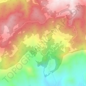
Name: Kadıköy topographic map, elevation, terrain.
Location: Kadıköy, Pamukova, Sakarya, Marmara Region, Turkey (40.52097 30.09043 40.56097 30.13043)
Average elevation: 687 m
Minimum elevation: 210 m
Maximum elevation: 1,085 m
Thank you for supporting this site ❤️
Make a donation
Make a donation
Gear up for your next adventure:
As an Amazon Associate, this site earns from qualifying purchases at no extra cost to you.