
Thank you for supporting this site ❤️
Make a donation
Make a donation
Gear up for your next adventure:
As an Amazon Associate, this site earns from qualifying purchases at no extra cost to you.
Penonomé topographic map
Click on the map to display elevation.
Thank you for supporting this site ❤️
Make a donation
Make a donation
Gear up for your next adventure:
As an Amazon Associate, this site earns from qualifying purchases at no extra cost to you.
About this map
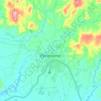
Name: Penonomé topographic map, elevation, terrain.
Location: Penonomé, Distrito Penonomé, Coclé, Panama (8.46572 -80.40207 8.58815 -80.32521)
Average elevation: 112 m
Minimum elevation: 24 m
Maximum elevation: 472 m
Thank you for supporting this site ❤️
Make a donation
Make a donation
Gear up for your next adventure:
As an Amazon Associate, this site earns from qualifying purchases at no extra cost to you.
Other topographic maps
Click on a map to view its topography, its elevation and its terrain.
Loma Grande
Panama > Coclé > Distrito Penonomé > Chiguirí Arriba > Loma Grande
Average elevation: 639 m