Geolocate

Indaial topographic map

Click on the map to display elevation.

Indaial

Indaial localiza-se no Vale do Itajaí, próxima a Blumenau, a uma latitude 26º53'52" sul e a uma longitude 49º13'54" oeste, estando a uma altitude de 64 metros. Possui uma área de 429,97 km².

About this map

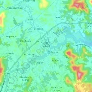
Name: Indaial topographic map, elevation, terrain.

Location: Indaial, Região Geográfica Imediata de Blumenau, Santa Catarina, Região Sul, 89082-085, Brasil (-26.93017 -49.28167 -26.85017 -49.20167)

Average elevation: 90 m

Minimum elevation: 32 m

Maximum elevation: 317 m

Gear up for your next adventure:

Camping Groundsheet - Protect your tent from moisture and dirt
🥾Approach Boots - Comfortable boots for hiking and climbing approaches
🥾Hiking Leggings - Comfortable leggings for outdoor activities
🔭Compact Monocular - One-handed bird watching and trail spotting
🧴Bear Spray Holster - Quick-access carry for essential Canadian wilderness safety

As an Amazon Associate, this site earns from qualifying purchases at no extra cost to you.