
Make a donation
Gear up for your next adventure:
As an Amazon Associate, this site earns from qualifying purchases at no extra cost to you.
Colfax topographic map
Click on the map to display elevation.
Make a donation
Gear up for your next adventure:
As an Amazon Associate, this site earns from qualifying purchases at no extra cost to you.
Colfax
Colfax is located in southeastern Washington at 46°53′3″N 117°21′49″W / 46.88417°N 117.36361°W / 46.88417; -117.36361 (46.884033, -117.363668), at an elevation of 1,962 feet (598 m). The nearest cities are Spokane, Pullman, Moscow, and Lewiston/Clarkston. The area is geologically interesting, lying in the midst of the fertile Palouse country in the middle of the Columbia River Plateau, with the Rocky Mountains to the east, the Channeled Scablands to the west, and the Snake River to the south.
Make a donation
Gear up for your next adventure:
As an Amazon Associate, this site earns from qualifying purchases at no extra cost to you.
About this map
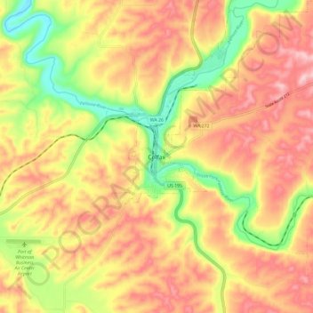
Name: Colfax topographic map, elevation, terrain.
Location: Colfax, Whitman County, Washington, 99111, United States (46.84017 -117.40435 46.92017 -117.32435)
Average elevation: 689 m
Minimum elevation: 573 m
Maximum elevation: 779 m
Make a donation
Gear up for your next adventure:
As an Amazon Associate, this site earns from qualifying purchases at no extra cost to you.