Le Puy-en-Velay topographic map
Interactive map
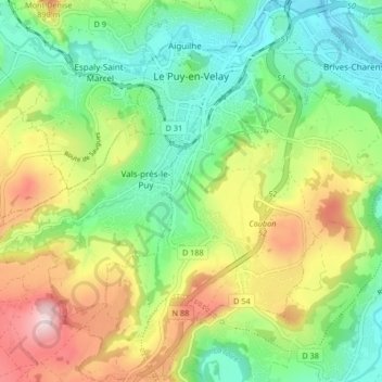
Click on the map to display elevation.
About this map
Name: Le Puy-en-Velay topographic map, elevation, terrain.
Average elevation: 737 m
Minimum elevation: 593 m
Maximum elevation: 979 m

Click on the map to display elevation.
Name: Le Puy-en-Velay topographic map, elevation, terrain.
Average elevation: 737 m
Minimum elevation: 593 m
Maximum elevation: 979 m