
Make a donation
Gear up for your next adventure:
As an Amazon Associate, this site earns from qualifying purchases at no extra cost to you.
Woodbury topographic map
Click on the map to display elevation.
Make a donation
Gear up for your next adventure:
As an Amazon Associate, this site earns from qualifying purchases at no extra cost to you.
About this map
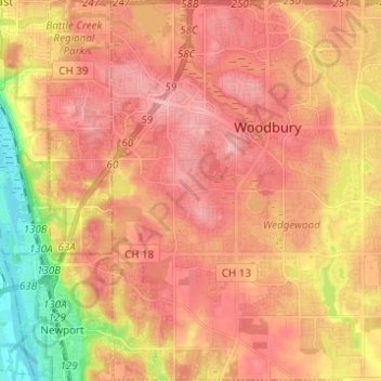
Name: Woodbury topographic map, elevation, terrain.
Location: Woodbury, Washington County, Minnesota, United States (44.86194 -92.98466 44.94926 -92.86244)
Average elevation: 297 m
Minimum elevation: 225 m
Maximum elevation: 335 m
Make a donation
Gear up for your next adventure:
As an Amazon Associate, this site earns from qualifying purchases at no extra cost to you.
Other topographic maps
Click on a map to view its topography, its elevation and its terrain.
Grey Cloud Island
United States > Minnesota > Washington County > Grey Cloud Island Township
Average elevation: 225 m
St. Croix River Boom Site Landing
United States > Minnesota > Washington County > Stillwater Township
Average elevation: 253 m
Twin Pine Mobile Home Park
United States > Minnesota > Washington County > Hugo
Average elevation: 282 m