
Make a donation
Gear up for your next adventure:
As an Amazon Associate, this site earns from qualifying purchases at no extra cost to you.
Begijnendijk topographic map
Click on the map to display elevation.
Make a donation
Gear up for your next adventure:
As an Amazon Associate, this site earns from qualifying purchases at no extra cost to you.
Begijnendijk
Begijnendijk ligt in de Zuiderkempen op een hoogte van 10-12 meter. In het noorden vindt men de Meerloop met het moerasgebied de Meren. Er zijn enkele kleiputten.
Make a donation
Gear up for your next adventure:
As an Amazon Associate, this site earns from qualifying purchases at no extra cost to you.
About this map
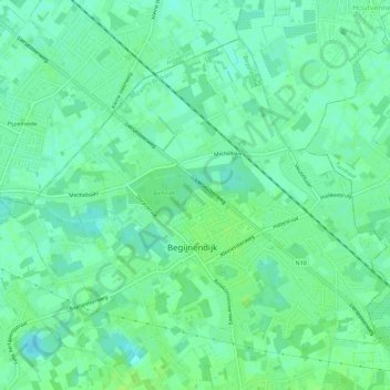
Name: Begijnendijk topographic map, elevation, terrain.
Location: Begijnendijk, Leuven, Vlaams-Brabant, België (51.00943 4.75306 51.03898 4.81124)
Average elevation: 12 m
Minimum elevation: 6 m
Maximum elevation: 18 m
Make a donation
Gear up for your next adventure:
As an Amazon Associate, this site earns from qualifying purchases at no extra cost to you.