
McKinley County topographic map
Interactive map
Click on the map to display elevation.
About this map
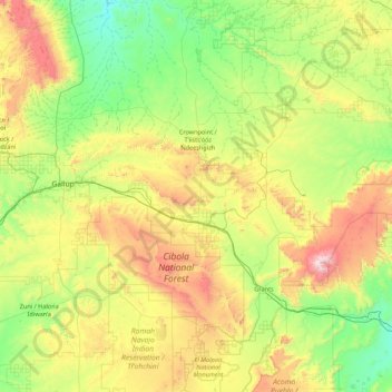
Name: McKinley County topographic map, elevation, terrain.
Location: McKinley County, Nouveau-Mexique, États-Unis (34.95902 -109.04680 36.00275 -107.30614)
Average elevation: 2,124 m
Minimum elevation: 1,672 m
Maximum elevation: 3,377 m
Other topographic maps
Click on a map to view its topography, its elevation and its terrain.
Cedar Crest
Cedar Crest, Bernalillo County, Nouveau-Mexique, 87008, États-Unis
Average elevation: 2,169 m
Española
États-Unis > Nouveau-Mexique > Española > Espanola
Española, Espanola, Santa Fe County, Nouveau-Mexique, 87567, États-Unis
Average elevation: 1,750 m