
Make a donation
Gear up for your next adventure:
As an Amazon Associate, this site earns from qualifying purchases at no extra cost to you.
Kufstein topographic map
Click on the map to display elevation.
Make a donation
Gear up for your next adventure:
As an Amazon Associate, this site earns from qualifying purchases at no extra cost to you.
Kufstein
Die Stadt liegt beiderseits des Inns, zwischen dem Hausberg Pendling und dem Maistaller Berg im Westen, dem Thierberg im Norden, dem Kaisergebirge und dem Stadtberg im Osten und dem Kufsteiner Wald im Süden. Die Stadt befindet sich auf rund 500 Meter Meereshöhe am Ausgang des alpinen Inntales und nur wenige Kilometer vom bayerischen Alpenvorland entfernt. Im Gemeindegebiet liegt auch das Kaisertal, das bis vor Kurzem letzte Tal Österreichs ohne Straßenanbindung (2006 wurde nach langem politischen Diskurs der Anna-Tunnel zwischen Kufstein und Ebbs gebaut).
Make a donation
Gear up for your next adventure:
As an Amazon Associate, this site earns from qualifying purchases at no extra cost to you.
About this map
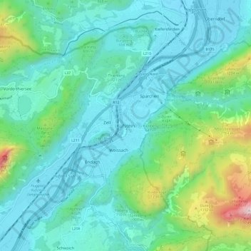
Name: Kufstein topographic map, elevation, terrain.
Location: Kufstein, Bezirk Kufstein, Tirol, 6330, Österreich (47.54300 12.12921 47.62300 12.20921)
Average elevation: 725 m
Minimum elevation: 463 m
Maximum elevation: 1,828 m
Make a donation
Gear up for your next adventure:
As an Amazon Associate, this site earns from qualifying purchases at no extra cost to you.