Geolocate

Marcelly topographic map

Click on the map to display elevation.

About this map
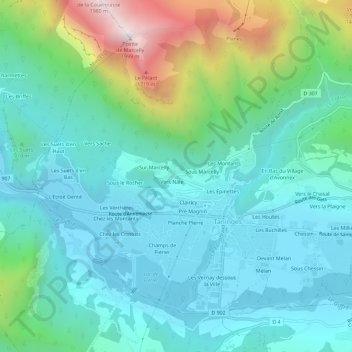
Name: Marcelly topographic map, elevation, terrain.

Location: Marcelly, Taninges, Bonneville, Haute-Savoie, Auvergne-Rhône-Alpes, France métropolitaine, 74440, France (46.09263 6.56296 46.13263 6.60296)

Average elevation: 912 m

Minimum elevation: 606 m

Maximum elevation: 1,973 m

Other topographic maps

Click on a map to view its topography, its elevation and its terrain.
74440

France > Auvergne-Rhône-Alpes > Haute-Savoie > Taninges > Avonnex

Average elevation: 886 m

Gear up for your next adventure:

🧣Merino Neck Gaiter - Protects against wind, sun, and cold at high altitudes
🥤Collapsible Travel Cup - Saves space and weight in your mess kit
🪜Heavy Duty Carabiners - Multi-use clips for securing gear to your backpack
🕯️Camping Lantern - Illuminates your entire campsite with high-efficiency LEDs
⛺Camping Essentials - All-in-one gear for a comfortable camping trip

As an Amazon Associate, this site earns from qualifying purchases at no extra cost to you.