Geolocate

Powell River topographic map

Click on the map to display elevation.

About this map

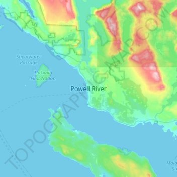
Name: Powell River topographic map, elevation, terrain.

Location: Powell River, City of Powell River, British Columbia, V8A 3A7, Canada (49.67568 -124.68441 49.99568 -124.36441)

Average elevation: 155 m

Minimum elevation: 0 m

Maximum elevation: 1,170 m

British Columbia trails, hiking, mountain biking, running and outdoor activities

Gear up for your next adventure:

🧥Fleece Jacket - Warm and lightweight jacket for layering
🥘Camping Cookware Set - Compact nesting pots and pans for trail cooking
🥾Light Hiking Boots - Lightweight and comfortable boots for day hikes
🔭Outdoor Binoculars - Lightweight binoculars for birdwatching and hiking
🥾Mountaineering Boots - Supportive boots for climbing and high-altitude hiking

As an Amazon Associate, this site earns from qualifying purchases at no extra cost to you.