
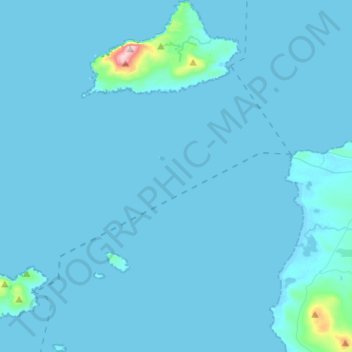
Clare Island ED topographic map
Interactive map
Click on the map to display elevation.
About this map
Name: Clare Island ED topographic map, elevation, terrain.
Average elevation: 12 m
Minimum elevation: -2 m
Maximum elevation: 456 m
Other topographic maps
Click on a map to view its topography, its elevation and its terrain.
Westport-Belmullet Municipal District
Westport-Belmullet Municipal District, County Mayo, Connacht, Irlande
Average elevation: 62 m
Clare Island
Clare Island, Westport-Belmullet Municipal District, County Mayo, Connacht, Irlande
Average elevation: 29 m
Belmullet
Belmullet, Belmullet ED, Westport-Belmullet Municipal District, County Mayo, Connacht, Irlande
Average elevation: 7 m
Glenagh
Glenagh, Béal Deirg Mór ED, Westport-Belmullet Municipal District, County Mayo, Connacht, Irlande
Average elevation: 208 m
Aille River
Aille River, Aghagower South ED, Westport-Belmullet Municipal District, County Mayo, Connacht, Irlande
Average elevation: 83 m
Owennadornaun ED
Owennadornaun ED, Westport-Belmullet Municipal District, County Mayo, Connacht, Irlande
Average elevation: 157 m
Aille River
Aille River, Aghagower South ED, Westport-Belmullet Municipal District, County Mayo, Connacht, Irlande
Average elevation: 65 m
Béal an Mhuirthead
Irlande > County Mayo > Béal an Mhuirthead
Béal an Mhuirthead, Westport-Belmullet Municipal District, County Mayo, Connacht, Irlande
Average elevation: 14 m
Fawnglass
Fawnglass, Clare Island ED, Westport-Belmullet Municipal District, County Mayo, Connacht, Irlande
Average elevation: 32 m
Cloonamanagh
Cloonamanagh, Owennadornaun ED, Westport-Belmullet Municipal District, County Mayo, Connacht, Irlande
Average elevation: 64 m