Geolocate

Ponlach topographic map

Click on the map to display elevation.

About this map

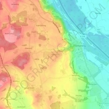
Name: Ponlach topographic map, elevation, terrain.

Location: Ponlach, Tittmoning, Landkreis Traunstein, Bayern, 84529, Deutschland (48.03890 12.73395 48.07890 12.77395)

Average elevation: 429 m

Minimum elevation: 358 m

Maximum elevation: 502 m

Other topographic maps

Click on a map to view its topography, its elevation and its terrain.

84529

Deutschland > Bayern > Landkreis Traunstein > Tittmoning > Kay > Mühlham

Average elevation: 466 m

Gear up for your next adventure:

🦶Anti-Blister Balm - Prevents friction and hotspots during long ascents
🧤Rechargeable Heated Gloves - Extreme warmth for Canadian winter expeditions
🛏️Sleeping Bag - Warm and compact sleeping bags for outdoor camping
🥾Waterproof Trail Shoes - Shoes designed to handle wet terrain
🗺️Topographic Maps - Detailed maps to explore trails, mountains, and wilderness areas

As an Amazon Associate, this site earns from qualifying purchases at no extra cost to you.