
Make a donation
Gear up for your next adventure:
As an Amazon Associate, this site earns from qualifying purchases at no extra cost to you.
Seigendorf topographic map
Click on the map to display elevation.
Make a donation
Gear up for your next adventure:
As an Amazon Associate, this site earns from qualifying purchases at no extra cost to you.
Seigendorf
Es liegt östlich von Hirschaid. Über die Kreisstraße BA 27 erreicht man nach einem Kilometer die Einfahrt Hirschaid der A 73. Durch den östlichen Ortsbereich verläuft die Staatsstraße 2210. Seigendorf liegt auf einer durchschnittlichen Höhe von 273 Metern über dem Meeresspiegel.
Make a donation
Gear up for your next adventure:
As an Amazon Associate, this site earns from qualifying purchases at no extra cost to you.
About this map
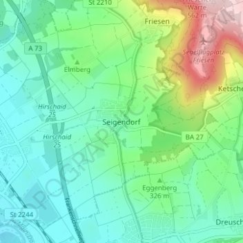
Name: Seigendorf topographic map, elevation, terrain.
Average elevation: 319 m
Minimum elevation: 238 m
Maximum elevation: 546 m
Make a donation
Gear up for your next adventure:
As an Amazon Associate, this site earns from qualifying purchases at no extra cost to you.