
Thank you for supporting this site ❤️
Make a donation
Make a donation
Gear up for your next adventure:
As an Amazon Associate, this site earns from qualifying purchases at no extra cost to you.
Paravy topographic map
Click on the map to display elevation.
Thank you for supporting this site ❤️
Make a donation
Make a donation
Gear up for your next adventure:
As an Amazon Associate, this site earns from qualifying purchases at no extra cost to you.
About this map
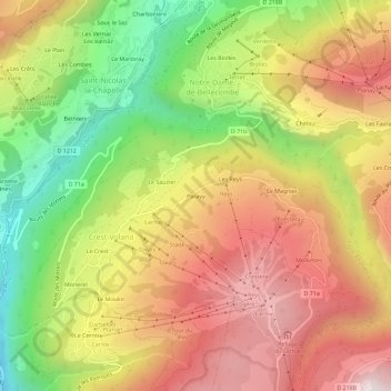
Name: Paravy topographic map, elevation, terrain.
Average elevation: 1,222 m
Minimum elevation: 690 m
Maximum elevation: 1,696 m
Thank you for supporting this site ❤️
Make a donation
Make a donation
Gear up for your next adventure:
As an Amazon Associate, this site earns from qualifying purchases at no extra cost to you.
Other topographic maps
Click on a map to view its topography, its elevation and its terrain.
Réserve naturelle de la Tourbière des Saisies - Beaufortain - Val d'Arly
France > Auvergne-Rhône-Alpes > Savoie > Crest-Voland
Average elevation: 1,559 m