Geolocate

Gangi topographic map

Click on the map to display elevation.

About this map
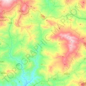
Name: Gangi topographic map, elevation, terrain.

Location: Gangi, Palermo, Sicily, 90024, Italy (37.66972 14.15173 37.82726 14.29439)

Average elevation: 802 m

Minimum elevation: 398 m

Maximum elevation: 1,371 m

Other topographic maps

Click on a map to view its topography, its elevation and its terrain.
Sorgente di Montescuro

Italy > Sicily > Palermo > Prizzi

Average elevation: 831 m

Bellacera

Italy > Sicily > Palermo > Santa Flavia

Average elevation: 162 m

San Carlo

Italy > Sicily > Palermo > Chiusa Sclafani

Average elevation: 291 m

Finale

Italy > Sicily > Palermo

Average elevation: 84 m

Santa Lucia

Italy > Sicily > Palermo > Cefalù

Average elevation: 51 m

Gear up for your next adventure:

🧣Evaporative Cooling Towel - Beat the heat during intense summer climbs
🥘Camping Cookware Set - Compact nesting pots and pans for trail cooking
🧳Compression Sacks - Maximize space in your backpack by shrinking gear
🔦LED Headlamp - Hands-free lighting for early morning starts or late finishes
🧊Insulated Water Bottle - Keeps drinks cold in summer and prevents freezing in winter

As an Amazon Associate, this site earns from qualifying purchases at no extra cost to you.