Geolocate

Serang topographic map

Click on the map to display elevation.

About this map

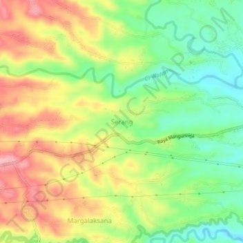
Name: Serang topographic map, elevation, terrain.

Location: Serang, West Java, 46414, Indonesia (-7.39016 108.04837 -7.35016 108.08837)

Average elevation: 470 m

Minimum elevation: 404 m

Maximum elevation: 545 m

Gear up for your next adventure:

🧥Thermal Layer - Insulating layer for cold outdoor conditions
🩹Compact First Aid Kit - Pre-packed essentials for common trail injuries
🗺️Topographic Maps - Detailed maps to explore trails, mountains, and wilderness areas
🏃Hydration Running Vest - Carry water and maps close to your body for speed
🥾Hiking Shorts - Breathable shorts suitable for summer hikes

As an Amazon Associate, this site earns from qualifying purchases at no extra cost to you.