Geolocate

Narayanpur topographic map

Click on the map to display elevation.

About this map

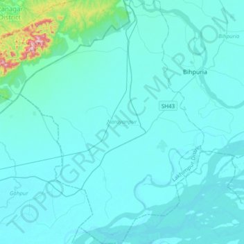
Name: Narayanpur topographic map, elevation, terrain.

Location: Narayanpur, Lakhimpur, Assam, India (26.82827 93.69810 27.09878 93.92778)

Average elevation: 103 m

Minimum elevation: 68 m

Maximum elevation: 592 m

Gear up for your next adventure:

🦶Anti-Blister Balm - Prevents friction and hotspots during long ascents
💡Solar Camping Lamp - Eco-friendly lighting for campsites
🔦UV Flashlight - Detect minerals or specific insects in the dark
🔦LED Headtorch - Bright and durable light for night activities
🧥Waterproof Hiking Jacket - Protect yourself from rain and wind while hiking

As an Amazon Associate, this site earns from qualifying purchases at no extra cost to you.