
Town of East Greenbush topographic map
Interactive map
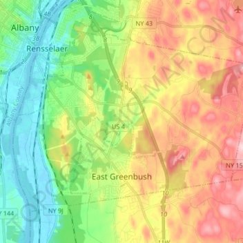
Click on the map to display elevation.
About this map
Name: Town of East Greenbush topographic map, elevation, terrain.
Average elevation: 89 m
Minimum elevation: -2 m
Maximum elevation: 213 m
The western section of the town, along the Hudson River is marked by bluffs that rise to an elevation of between 100 and 300 feet. The little flat land that exists along the river is on the Papscanee Island. Papscanee Island is actually a peninsula, separated from the rest of the town by the Papscanee Creek. The town then spreads out as rolling hills rising towards the east. Mill Creek (formerly Tierken Kill) and Morden Creek are the principal streams of the town.
Other topographic maps
Click on a map to view its topography, its elevation and its terrain.
Clinton Heights
United States > New York > Rensselaer County > Town of East Greenbush
Clinton Heights, Town of East Greenbush, Rensselaer County, New York, 12144, United States
Average elevation: 49 m
Troy
United States > New York > Rensselaer County > Troy
Troy, City of Troy, Rensselaer County, New York, 12183, United States
Average elevation: 137 m
Mountain View
United States > New York > Rensselaer County > Mountain View
Mountain View, Town of Brunswick, Rensselaer County, New York, 12198-9998, United States
Average elevation: 114 m