
Make a donation
Gear up for your next adventure:
As an Amazon Associate, this site earns from qualifying purchases at no extra cost to you.
Aglasterhausen topographic map
Click on the map to display elevation.
Make a donation
Gear up for your next adventure:
As an Amazon Associate, this site earns from qualifying purchases at no extra cost to you.
About this map
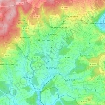
Name: Aglasterhausen topographic map, elevation, terrain.
Average elevation: 261 m
Minimum elevation: 181 m
Maximum elevation: 405 m
Make a donation
Gear up for your next adventure:
As an Amazon Associate, this site earns from qualifying purchases at no extra cost to you.
Other topographic maps
Click on a map to view its topography, its elevation and its terrain.
Hollerbach
Deutschland > Baden-Württemberg > Neckar-Odenwald-Kreis > Buchen (Odenwald)
Average elevation: 395 m
Katzenbuckel
Deutschland > Baden-Württemberg > Neckar-Odenwald-Kreis > Waldbrunn
Auf der Kuppe des Katzenbuckels steht der 18 m hohe Aussichtsturm Katzenbuckel, der 1820 aus Sandstein erbaut wurde. Er bietet Ausblicke über die bewaldeten Kuppen und Bergrücken des Odenwaldes, zum Spessart und zu den Schwäbisch-Fränkischen Waldbergen. Nach Nordwesten sieht man zur höchsten Erhebung des…
Average elevation: 456 m