Geolocate

Sabang topographic map

Click on the map to display elevation.

About this map

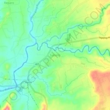
Name: Sabang topographic map, elevation, terrain.

Location: Sabang, Tuy, Batangas, Calabarzon, Philippines (14.03757 120.68798 14.07757 120.72798)

Average elevation: 53 m

Minimum elevation: 16 m

Maximum elevation: 118 m

Other topographic maps

Click on a map to view its topography, its elevation and its terrain.

Luna

Philippines > Batangas > Tuy

Average elevation: 75 m

Palico River

Philippines > Batangas > Tuy > Sabang > Palico

Average elevation: 40 m

Gear up for your next adventure:

🔨Vehicle Emergency Tool - Safety tool for remote road trips to trailheads
🚲Heavy Duty Bike Lock - Secure your bike at the trailhead or during stops
🔥Emergency Fire Starter - Reliable ignition source for all weather conditions
🥾Waterproof Hiking Boots - Essential footwear for rugged terrain and wet Canadian trails
🧢Sun Hat - Wide-brim hat for sun protection

As an Amazon Associate, this site earns from qualifying purchases at no extra cost to you.