
San Isidro de El General topographic map
Interactive map
Click on the map to display elevation.
About this map
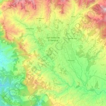
Name: San Isidro de El General topographic map, elevation, terrain.
Average elevation: 838 m
Minimum elevation: 61 m
Maximum elevation: 2,078 m
San Isidro de El General cuenta con un área de 191,53 km² y una altitud media de 702 m s. n. m.
Other topographic maps
Click on a map to view its topography, its elevation and its terrain.
Los Crestones
Costa Rica > Cantón Pérez Zeledón > Rivas
Los Crestones, Rivas, Cantón Pérez Zeledón, Provincia San José, 11904, Costa Rica
Average elevation: 3,442 m