
Make a donation
Gear up for your next adventure:
As an Amazon Associate, this site earns from qualifying purchases at no extra cost to you.
Town of Pound Ridge topographic map
Click on the map to display elevation.
Make a donation
Gear up for your next adventure:
As an Amazon Associate, this site earns from qualifying purchases at no extra cost to you.
About this map
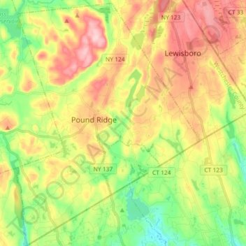
Name: Town of Pound Ridge topographic map, elevation, terrain.
Average elevation: 156 m
Minimum elevation: 67 m
Maximum elevation: 262 m
Make a donation
Gear up for your next adventure:
As an Amazon Associate, this site earns from qualifying purchases at no extra cost to you.
Other topographic maps
Click on a map to view its topography, its elevation and its terrain.
Wilmot Woods
United States > New York > Westchester County > City of New Rochelle
Average elevation: 70 m
Forest Knolls
United States > New York > Westchester County > City of New Rochelle
Average elevation: 34 m
Make a donation
Gear up for your next adventure:
As an Amazon Associate, this site earns from qualifying purchases at no extra cost to you.
Heath Ridge
United States > New York > Westchester County > Village of Scarsdale
Average elevation: 66 m
Cross River
United States > New York > Westchester County > Town of Lewisboro
Average elevation: 155 m
Colonial Acres
United States > New York > Westchester County > Scarsdale > Colonial Acres
Average elevation: 55 m
Make a donation
Gear up for your next adventure:
As an Amazon Associate, this site earns from qualifying purchases at no extra cost to you.
Beechmont
United States > New York > Westchester County > City of New Rochelle > Beechmont
Average elevation: 31 m
Parkside
United States > New York > Westchester County > City of Mount Vernon > Parkside
Average elevation: 27 m