
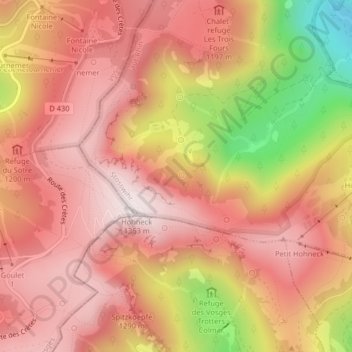
La Grotte Dagobert topographic map
Interactive map
Click on the map to display elevation.
About this map
Name: La Grotte Dagobert topographic map, elevation, terrain.
Average elevation: 1,121 m
Minimum elevation: 660 m
Maximum elevation: 1,352 m
Other topographic maps
Click on a map to view its topography, its elevation and its terrain.
Réserve naturelle du Frankenthal-Missheimle
France > Grand Est > Stosswihr
Réserve naturelle du Frankenthal-Missheimle, Sentier de la Bloy, Stosswihr, Colmar-Ribeauvillé, Haut-Rhin, Grand Est, France métropolitaine, 68140, France
Average elevation: 1,003 m
Lac de Schiessrothried
France > Grand Est > Stosswihr
Lac de Schiessrothried, Sentier des Couloirs, Stosswihr, Colmar-Ribeauvillé, Haut-Rhin, Grand Est, France métropolitaine, 68140, France
Average elevation: 1,074 m
Petit Cervin
France > Grand Est > Stosswihr
Petit Cervin, Sentier du Falimont, Stosswihr, Colmar-Ribeauvillé, Haut-Rhin, Grand Est, France métropolitaine, 68140, France
Average elevation: 1,131 m