
Tirich Mir topographic map
Interactive map
Click on the map to display elevation.
About this map
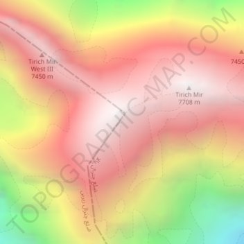
Name: Tirich Mir topographic map, elevation, terrain.
Location: Tirich Mir, Chitrāl District, Jaiber Pastunjuá, Pakistán (36.25404 71.84122 36.25414 71.84132)
Average elevation: 6,886 m
Minimum elevation: 5,538 m
Maximum elevation: 7,666 m
Other topographic maps
Click on a map to view its topography, its elevation and its terrain.
Istor-o-Nal
Istor-o-Nal, Chitrāl District, Jaiber Pastunjuá, Pakistán
Average elevation: 6,853 m
Chitral
Pakistán > Jaiber Pastunjuá > Chitral
Chitral, Chitrāl District, Jaiber Pastunjuá, Pakistán
Average elevation: 2,047 m
ایبٹ آباد
Pakistán > Jaiber Pastunjuá > ایبٹ آباد
ایبٹ آباد, Abbottābād District, Jaiber Pastunjuá, 22010, Pakistán
Average elevation: 1,365 m