
Côn Đảo topographic map
Interactive map
Click on the map to display elevation.
About this map
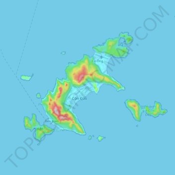
Name: Côn Đảo topographic map, elevation, terrain.
Location: Côn Đảo, Province de Ba Ria-Vung Tau, Viêt Nam (8.62806 106.53642 8.77955 106.74371)
Average elevation: 18 m
Minimum elevation: -2 m
Maximum elevation: 565 m
Other topographic maps
Click on a map to view its topography, its elevation and its terrain.
Thành phố Vũng Tàu
Viêt Nam > Province de Ba Ria-Vung Tau > Thành phố Vũng Tàu
Thành phố Vũng Tàu, Province de Ba Ria-Vung Tau, Viêt Nam
Average elevation: 3 m