Geolocate

Kochi topographic map

Click on the map to display elevation.

About this map

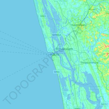
Name: Kochi topographic map, elevation, terrain.

Location: Kochi, Ernakulam, Kerala, 682001, India (9.80790 76.08444 10.12790 76.40444)

Average elevation: 4 m

Minimum elevation: -4 m

Maximum elevation: 64 m

Other topographic maps

Click on a map to view its topography, its elevation and its terrain.

Willingdon Island

India > Kerala > Kochi > Kochi

Average elevation: 4 m

Elamkunnapuzha

India > Kerala > Kochi > Elamkunnapuzha

Average elevation: 2 m

Vypin

India > Kerala > Kochi > Cherai

Average elevation: 3 m

Kumbalanghi

India > Kerala > Kochi > Kochi

Average elevation: 3 m

Gear up for your next adventure:

🥾Mountain Hiking Boots - High-traction boots for rocky terrain
🧰Survival Kit - Essential gear for emergencies in the wilderness
🥾Trekking Poles - Adjustable trekking poles to reduce knee stress and improve stability
🧦Crew Hiking Socks - Comfortable socks for long-distance hikes
🥾Trail Hiking Shoes - Durable shoes designed for rugged trails

As an Amazon Associate, this site earns from qualifying purchases at no extra cost to you.