Geolocate

Valdecabras topographic map

Click on the map to display elevation.

About this map

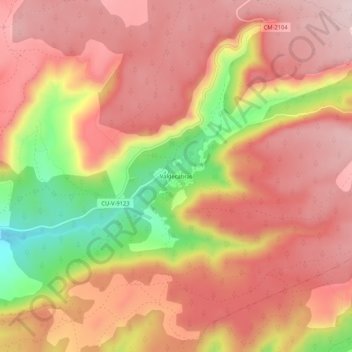
Name: Valdecabras topographic map, elevation, terrain.

Location: Valdecabras, Cuenca, Castilla-La Mancha, España (40.13899 -2.05573 40.17899 -2.01573)

Average elevation: 1,271 m

Minimum elevation: 1,063 m

Maximum elevation: 1,381 m

Other topographic maps

Click on a map to view its topography, its elevation and its terrain.

Rio Júcar

España > Castilla-La Mancha > Cuenca

Average elevation: 955 m

Embalse de La Toba

España > Castilla-La Mancha > Cuenca

Average elevation: 1,261 m

Gear up for your next adventure:

🧢Hiking Sun Hat - Wide-brimmed protection for exposed mountain ridges
🥾Durable Hiking Shoes - Long-lasting shoes for frequent hiking
🥾Hiking Shoes - Durable and comfortable shoes for trail hiking
🧼Biodegradable Camp Soap - Environmentally friendly cleaning for gear and body
Camping Tent - Weather-resistant tents suitable for 2 to 6 people

As an Amazon Associate, this site earns from qualifying purchases at no extra cost to you.