Geolocate

Bannockburn topographic map

Click on the map to display elevation.

About this map

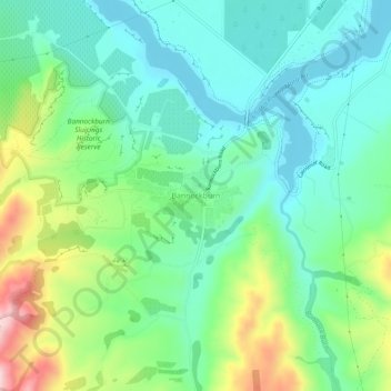
Name: Bannockburn topographic map, elevation, terrain.

Location: Bannockburn, Cromwell Community, Central Otago District, Otago, New Zealand (-45.10837 169.14001 -45.06837 169.18001)

Average elevation: 279 m

Minimum elevation: 192 m

Maximum elevation: 491 m

Other topographic maps

Click on a map to view its topography, its elevation and its terrain.

Gear up for your next adventure:

🧦Merino Wool Socks - Moisture-wicking comfort for long-distance hiking
🔋Lithium AA Batteries - Long-lasting power that performs in extreme cold
Camping Groundsheet - Protect your tent from moisture and dirt
🩹Moleskin Blister Pads - Direct protection for painful foot pressure points
🧴Outdoor Sunscreen - High SPF protection for high-altitude UV exposure

As an Amazon Associate, this site earns from qualifying purchases at no extra cost to you.