
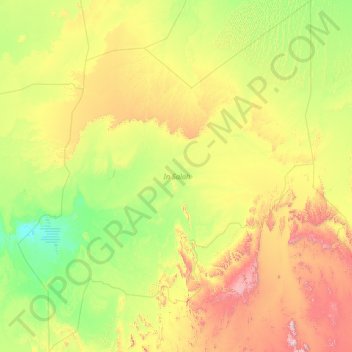
circonscription administrative d'In Salah topographic map
Interactive map
Click on the map to display elevation.
About this map
Name: circonscription administrative d'In Salah topographic map, elevation, terrain.
Location: circonscription administrative d'In Salah, Tamanrasset, RADP (24.63672 0.93302 29.75830 5.77701)
Average elevation: 484 m
Minimum elevation: 120 m
Maximum elevation: 2,171 m
Other topographic maps
Click on a map to view its topography, its elevation and its terrain.
In Guezzam
RADP > Tamanrasset > In Guezzam
In Guezzam, Daïra d'In Guezzam, circonscription administrative In Guezzam, Tamanrasset, RADP
Average elevation: 534 m
Hoggar Mountains
RADP > Tamanrasset > Tamanghasset
Hoggar Mountains, Tamanghasset, Daïra de Tamanrasset, Tamanrasset, RADP
Average elevation: 2,451 m