
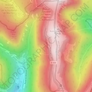
Réserve naturelle des Hautes Chaumes du Rothenbach topographic map
Interactive map
Click on the map to display elevation.
About this map
Name: Réserve naturelle des Hautes Chaumes du Rothenbach topographic map, elevation, terrain.
Average elevation: 1,014 m
Minimum elevation: 591 m
Maximum elevation: 1,301 m
Other topographic maps
Click on a map to view its topography, its elevation and its terrain.
Réserve naturelle du massif du Grand Ventron
France > Grand Est > Haut-Rhin > Wildenstein
Réserve naturelle du massif du Grand Ventron, Wildenstein, Thann-Guebwiller, Haut-Rhin, Grand Est, France métropolitaine, 68820, France
Average elevation: 878 m