
Nationalpark Thy topographic map
Interactive map
Click on the map to display elevation.
About this map
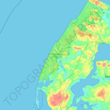
Name: Nationalpark Thy topographic map, elevation, terrain.
Location: Nationalpark Thy, Jutland du Nord, Danemark (56.70039 8.21195 57.11759 8.68163)
Average elevation: 9 m
Minimum elevation: -5 m
Maximum elevation: 81 m
Other topographic maps
Click on a map to view its topography, its elevation and its terrain.
Vorup
Danemark > Jutland du Nord > Vorup
Vorup, Thisted Kommune, Jutland du Nord, Danemark
Average elevation: 19 m
Thisted
Thisted, Thisted Kommune, Jutland du Nord, Danemark
Average elevation: 17 m
Snedsted
Snedsted, Thisted Kommune, Jutland du Nord, 7752, Danemark
Average elevation: 21 m
Vendsyssel-Thy
Vendsyssel-Thy, Brønderslev Kommune, Jutland du Nord, Danemark
Average elevation: 9 m