Geolocate

Berastagi topographic map

Click on the map to display elevation.

About this map

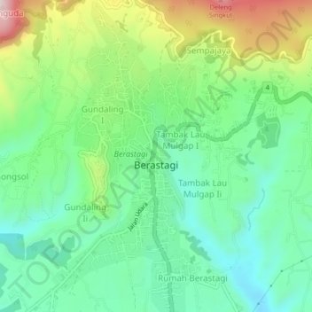
Name: Berastagi topographic map, elevation, terrain.

Location: Berastagi, Kabupaten Karo, North Sumatra, Sumatra, Indonesia (3.17389 98.49560 3.21399 98.51452)

Average elevation: 1,418 m

Minimum elevation: 1,280 m

Maximum elevation: 1,707 m

Other topographic maps

Click on a map to view its topography, its elevation and its terrain.

Sukanalu

Indonesia > North Sumatra > Kabupaten Karo

Average elevation: 1,206 m

Kampung Dalam

Indonesia > North Sumatra > Kabupaten Karo

Average elevation: 1,201 m

Gear up for your next adventure:

🥘Camping Cookware Set - Compact nesting pots and pans for trail cooking
🧣Merino Neck Gaiter - Protects against wind, sun, and cold at high altitudes
🧥Thermal Layer - Insulating layer for cold outdoor conditions
🦟Insect Repellent - Keep mosquitoes and black flies away in wooded areas
👖Convertible Hiking Pants - Zip-off legs to adapt to changing weather conditions

As an Amazon Associate, this site earns from qualifying purchases at no extra cost to you.