
Make a donation
Gear up for your next adventure:
As an Amazon Associate, this site earns from qualifying purchases at no extra cost to you.
Cerro del Bolsón topographic map
Click on the map to display elevation.
Make a donation
Gear up for your next adventure:
As an Amazon Associate, this site earns from qualifying purchases at no extra cost to you.
Cerro del Bolsón
While not of great height compared to the 6000 metre-plus peaks of the main chain of the Andes to the west, Bolsón is notable for its high topographic prominence (it ranks 69th in the world), resulting from its separation from the main chain by a relatively low saddle.
Make a donation
Gear up for your next adventure:
As an Amazon Associate, this site earns from qualifying purchases at no extra cost to you.
About this map
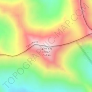
Name: Cerro del Bolsón topographic map, elevation, terrain.
Average elevation: 5,057 m
Minimum elevation: 4,593 m
Maximum elevation: 5,541 m
Make a donation
Gear up for your next adventure:
As an Amazon Associate, this site earns from qualifying purchases at no extra cost to you.
Other topographic maps
Click on a map to view its topography, its elevation and its terrain.
Make a donation
Gear up for your next adventure:
As an Amazon Associate, this site earns from qualifying purchases at no extra cost to you.
Antofagasta de la Sierra
Antofagasta de la Sierra is a high altitude settlement, the majority of its inhabitants are descended from the Diaguitas and Atacameños.
Average elevation: 3,382 m