
Anand topographic map
Click on the map to display elevation.
Anand
Anand is located at 22°34′N 72°56′E / 22.57°N 72.93°E / 22.57; 72.93. It has an average elevation of 39 metres (127 feet). The city has an area of 22.7 square kilometres, and the urban area of Anand City is 172 square kilometres including 25 villages around the city.
About this map
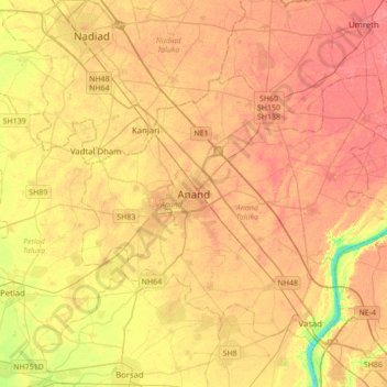
Name: Anand topographic map, elevation, terrain.
Location: Anand, Anand City Taluka, Anand, Gujarat, 388001, India (22.39866 72.80272 22.71866 73.12272)
Average elevation: 40 m
Minimum elevation: 4 m
Maximum elevation: 59 m