
McConnell topographic map
Interactive map
Click on the map to display elevation.
About this map
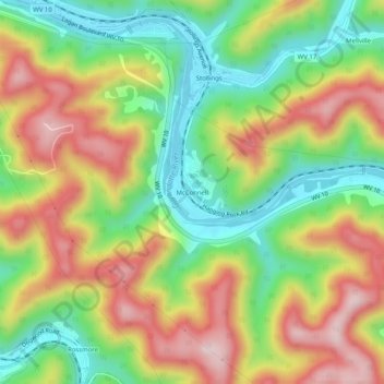
Name: McConnell topographic map, elevation, terrain.
Location: McConnell, Logan County, West Virginia, 25646, United States (37.80566 -81.98679 37.84566 -81.94679)
Average elevation: 359 m
Minimum elevation: 195 m
Maximum elevation: 552 m
Other topographic maps
Click on a map to view its topography, its elevation and its terrain.
Bradshaw
United States > West Virginia > Logan County
Bradshaw, Logan County, West Virginia, 25652, United States
Average elevation: 393 m
Sovereign
United States > West Virginia > Logan County
Sovereign, Logan County, West Virginia, 25022, United States
Average elevation: 457 m