
Make a donation
Gear up for your next adventure:
As an Amazon Associate, this site earns from qualifying purchases at no extra cost to you.
Pordic topographic map
Click on the map to display elevation.
Make a donation
Gear up for your next adventure:
As an Amazon Associate, this site earns from qualifying purchases at no extra cost to you.
Pordic
D’une superficie de 2 894 hectares, la commune est située au bord de la Manche, à environ 10 km au nord-ouest de la ville de Saint-Brieuc. Avec une altitude moyenne d’environ 100 m, elle occupe une partie du plateau qui entoure la baie de Saint-Brieuc. Ce plateau est entaillé par des vallées profondes, dont plusieurs délimitent le territoire de la commune (Parfond de Gouët, Rodo, Ic, ruisseau du Vau Madec).
Make a donation
Gear up for your next adventure:
As an Amazon Associate, this site earns from qualifying purchases at no extra cost to you.
About this map
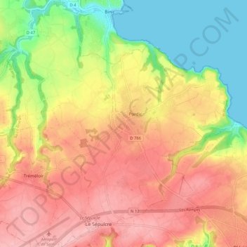
Name: Pordic topographic map, elevation, terrain.
Average elevation: 77 m
Minimum elevation: -3 m
Maximum elevation: 140 m
Make a donation
Gear up for your next adventure:
As an Amazon Associate, this site earns from qualifying purchases at no extra cost to you.
Other topographic maps
Click on a map to view its topography, its elevation and its terrain.
Make a donation
Gear up for your next adventure:
As an Amazon Associate, this site earns from qualifying purchases at no extra cost to you.