Geolocate

Gaighat topographic map

Click on the map to display elevation.

About this map

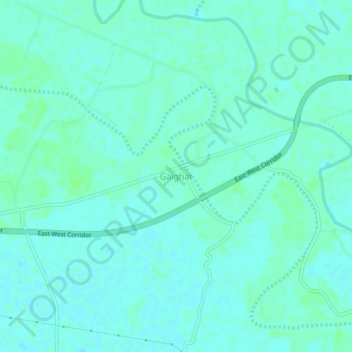
Name: Gaighat topographic map, elevation, terrain.

Location: Gaighat, Muzaffarpur, Bihar, 845435, India (26.11379 85.63413 26.15379 85.67413)

Average elevation: 50 m

Minimum elevation: 47 m

Maximum elevation: 54 m

Gear up for your next adventure:

🥾Lightweight Hiking Shoes - Comfortable shoes for day hikes
🧰Survival Kit - Essential gear for emergencies in the wilderness
🧳Compression Sacks - Maximize space in your backpack by shrinking gear
🕶️Polarized Sunglasses - Protect your eyes with durable polarized lenses
🥾Waterproof Hiking Shoes - Durable shoes for wet and rugged trails

As an Amazon Associate, this site earns from qualifying purchases at no extra cost to you.