Geolocate

Peroblasco topographic map

Click on the map to display elevation.

About this map

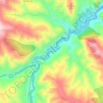
Name: Peroblasco topographic map, elevation, terrain.

Location: Peroblasco, Munilla, La Rioja, 26589, España (42.17845 -2.27771 42.21845 -2.23771)

Average elevation: 873 m

Minimum elevation: 654 m

Maximum elevation: 1,129 m

Gear up for your next adventure:

🧴First Aid Kit - Essential first aid supplies for outdoor emergencies
🚲MTB Frame Bag - Carry tools and maps directly on your bicycle frame
🎒Backpack Rain Cover - External shield to keep your entire pack dry
🛌Insulated Sleeping Pad - Critical thermal barrier between you and the cold ground
🧣Merino Neck Gaiter - Protects against wind, sun, and cold at high altitudes

As an Amazon Associate, this site earns from qualifying purchases at no extra cost to you.