Geolocate

Andrín topographic map

Click on the map to display elevation.

About this map

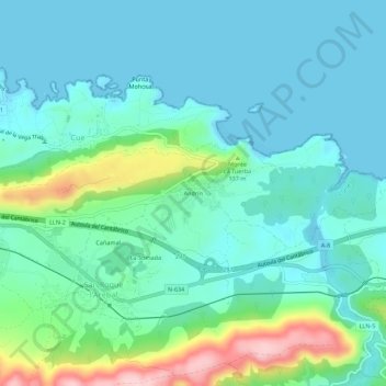
Name: Andrín topographic map, elevation, terrain.

Location: Andrín, San Roque l'Acebal, Llanes, Asturias, 33596, España (43.38641 -4.73801 43.42641 -4.69801)

Average elevation: 50 m

Minimum elevation: -3 m

Maximum elevation: 233 m

Gear up for your next adventure:

🧦Merino Wool Socks - Moisture-wicking comfort for long-distance hiking
🔥Camping Stove - Portable stoves to cook outdoors with ease
💡LED Camping Lantern - Illuminate your campsite with long-lasting lanterns
🧰Survival Kit - Essential gear for emergencies in the wilderness
🧦Crew Hiking Socks - Comfortable socks for long-distance hikes

As an Amazon Associate, this site earns from qualifying purchases at no extra cost to you.