Geolocate

Sector 44 topographic map

Click on the map to display elevation.

About this map

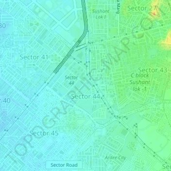
Name: Sector 44 topographic map, elevation, terrain.

Location: Sector 44, Gurgaon, Gurugram, Haryana, India (28.44593 77.06655 28.45885 77.07948)

Average elevation: 238 m

Minimum elevation: 230 m

Maximum elevation: 264 m

Other topographic maps

Click on a map to view its topography, its elevation and its terrain.

Sultanpur National Park

India > Haryana > Gurugram

Average elevation: 216 m

Wazirabad

India > Haryana > Gurugram

Average elevation: 241 m

Gear up for your next adventure:

🧥Softshell Jacket - Windproof and breathable jacket for hiking
🛶Kayak Dry Bag - Waterproof storage for kayaking adventures
🥾Trail Running Boots - Durable shoes designed for trail running
💧Collapsible Water Bottle - Space-saving water bottle for outdoor activities
🏕️Camping Hammock - Integrated protection for sleeping between trees

As an Amazon Associate, this site earns from qualifying purchases at no extra cost to you.