
Thank you for supporting this site ❤️
Make a donation
Make a donation
Gear up for your next adventure:
As an Amazon Associate, this site earns from qualifying purchases at no extra cost to you.
Fuentemilanos topographic map
Click on the map to display elevation.
Thank you for supporting this site ❤️
Make a donation
Make a donation
Gear up for your next adventure:
As an Amazon Associate, this site earns from qualifying purchases at no extra cost to you.
About this map
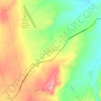
Name: Fuentemilanos topographic map, elevation, terrain.
Location: Fuentemilanos, Ségovie, Castille-et-León, Espagne (40.85490 -4.24786 40.89490 -4.20786)
Average elevation: 1,008 m
Minimum elevation: 942 m
Maximum elevation: 1,076 m
Thank you for supporting this site ❤️
Make a donation
Make a donation
Gear up for your next adventure:
As an Amazon Associate, this site earns from qualifying purchases at no extra cost to you.